
China's String of Pearls Strategy
- Posted by YUVA IAS
- Posted on {{formatDate('Tue Mar 09 2021 11:37:39 GMT+0530 (India Standard Time)') }}
China's String of Pearls Strategy
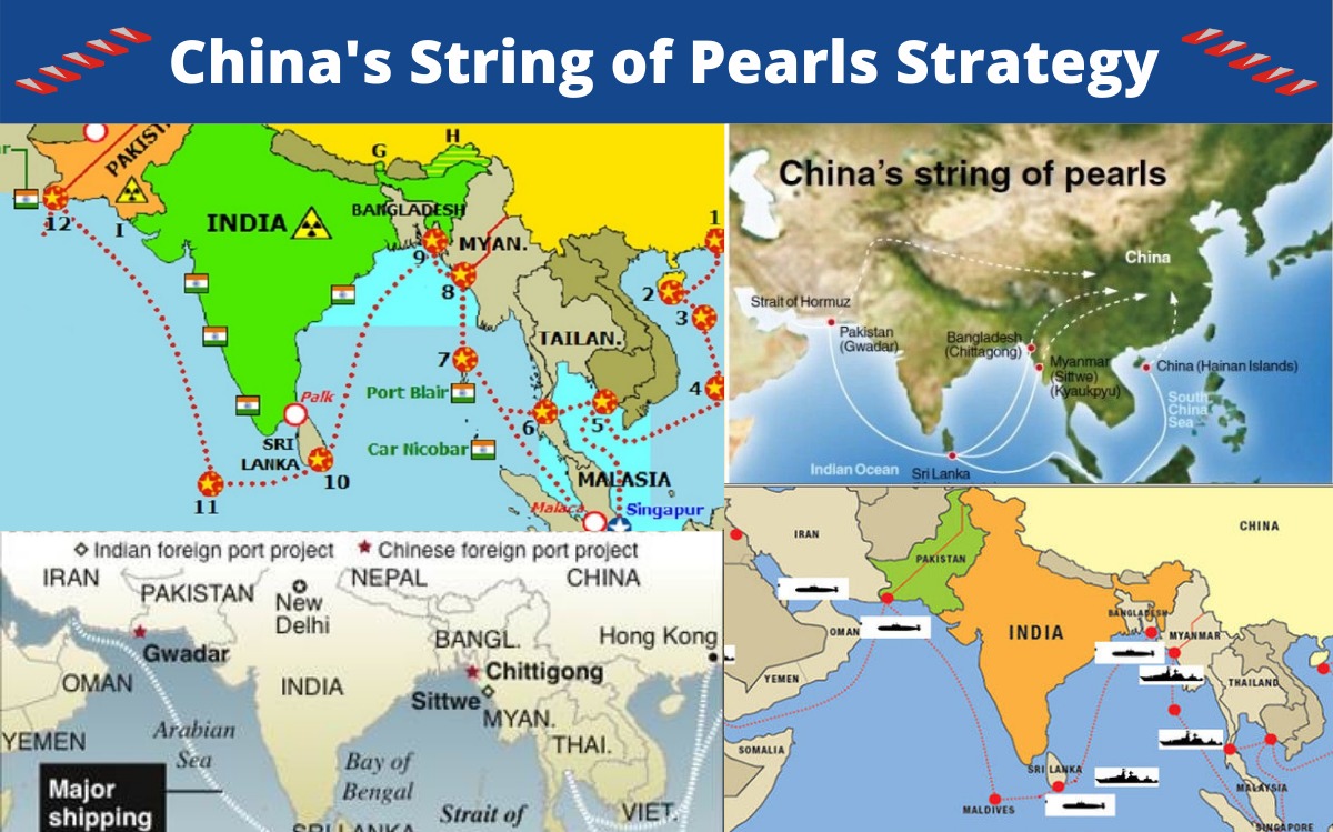
China’s String of Pearls strategy is the name given to a geopolitical strategy adopted by China arising as foreign oil becomes a center of gravity critical to China’s energy needs. This policy on the face of it appears to be an attempt by China to have an increased access to various ports and airfields in the South Asian region and at the same time to developing special diplomatic relations with these countries.
This seems to be a strategic move as China is establishing these pearls or a series of nodes of military and economic power thus enhancing its overall influence in these regions. A question posed by the “String of Pearls” is the uncertainty of whether China’s growing influence is in accordance with Beijing’s stated policy of “peaceful development,” or if China one day will make a bid for regional primacy. China gives the impression that it is interested in having a more powerful role to play on the global stage and thus evoking concerns in its neighbours, especially India, as being threatening. However, China’s development of these strategic geopolitical “pearls” has been non-confrontational, with no evidence of imperial or neo-colonial ambition, whatsoever.
THE PEARLS AND THEIR STRATEGIC SIGNIFICANCE
A few strategists in India and US have been using the term String of pearls to designate those areas where China is establishing its bases. These bases have been given the term ‘pearls’. Each pearl in the string is a nexus of Chinese geopolitical influence or military presence, which stretches from Hainan Island to Gwadar.
GWADAR, PAKISTAN
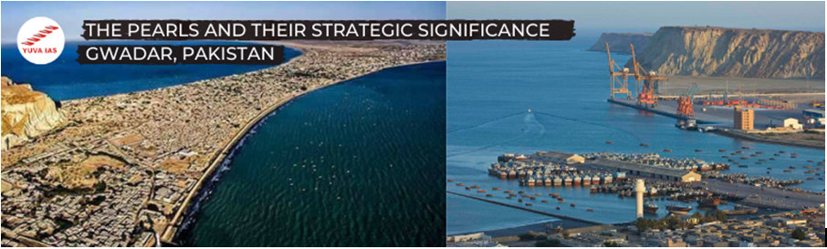
Gwadar port is a small fishing village, 450 miles west of Karachi and 75 km east of Iran border , and was identified by Pakistan as a potential port location in 1964 but lacked the means to develop. It is a deep sea , warm water port situated in the Balochistan province of Pakistan at the apex of Arabian sea and entrance of Persian gulf.
The port facility at Gwadar is a win-win prospect for both China and Pakistan. The port at Karachi currently handles 90 percent of Pakistan’s sea-borne trade, but because of its proximity to India, it is extremely vulnerable to blockade. This happened during the India-Pakistan War of 1971 and was threatened again during the Kargil conflict of 1999.
The port is strategically located between three important regions – Oil rich Middle East, heavily populated Pakistan and the Central Asian Region. A modern port at Gwadar would enhance Pakistan’s strategic depth along its coastline with respect to India.
Hambantota, SriLanka
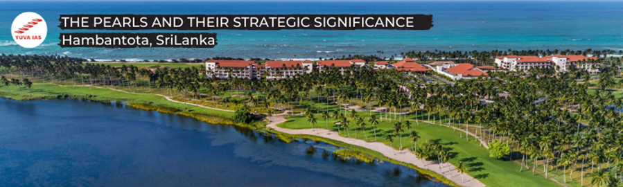
Hambantota is a rural town in the SE coast of Srilanka. As per the 2007 agreement, development of Hambantota included: -
- Developing a container port
- Developing a bunkering system
- Establishing an oil refinery
- Setting up an airport and other facilities
The approximate expenditure in setting up Hambantota was $1 Bn of which 85% will be financed by China over the next fifteen years.
Chittagong, Bangladesh
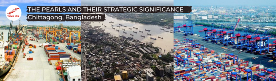
Chittagong is the largest seaport in Bangladesh. China is developing a container port facility a Chittagong. However, it is important to note here that there has been no further word on this development probably because of the regime change in Bangladesh which is India friendly.
Sittwe, Myanmar

Among the many ventures of China in Myanmar, the following two are the most crucial: -
The gas pipeline from Myanmar’s West Arakan state to Yunnan province.
Using Sittwe Port as a sea gateway.
According to the 1992 agreement, China was ready to modernize Myanmar’s naval facilities in return for the permission to use the Coco Islands. China undertook building a deep sea port (Kyaukpyu); road construction from Kunmig to Sittwe for which a feasibility study was done in 2005 and is also funding the road construction from Rangoon to Akyab. From 2013, Chinese oil tankers from the Middle East and Africa will be able to cross the Bay of Bengal to dock at Myanmar’s Sittwe and Kyaukphyu ports from where their cargo will be transported through pipelines to Yunnan. The transport time of fuel that bypasses the Malacca Strait in this way will be cut by a week.
Coco Islands
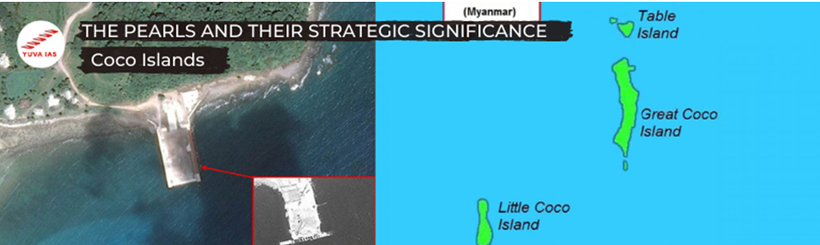
Coco islands are a pair of strategically important islands located in the East Indian oceanOcean politically administered by Burma under Yangon division. The Great Coco Islands (10×2) and Small Coco Islands (5×1) are separated from each other by Alexandra Channel. They are separated from the Andaman by Coco Channel; Myanmar – 300 km N
Historically, these islands were a part of India under British rule but due to lack of close supervision, they were transferred to Myanmar. These islands were supposedly leased to the People’s Republic of China since 1994, according to various amateur sources. The government of Burma and that of the People’s Republic of China do not comment on such manner.
Strait of Malacca
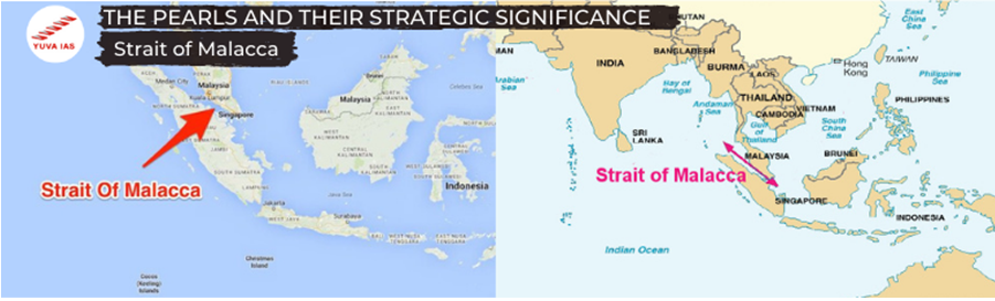
Strait of Malacca is a narrow 805km stretch of water between Peninsular Malaysia and Indonesian island of Sumatra. At the Philips Channel, this Strait narrows down to 2.8 km, thus becoming one of the world’s most significant choke points.
Straits of Malacca and Hormuz have become crucial waterways for China. Close cooperation with Myanmar and Pakistan thus also becomes a crucial issue. From economic and strategic perspectives, Strait of Malacca is one of the most important shipping lanes of the world. This Strait is economically significant for China in that 50,000 vessels pass through it each year and almost 80% of China’s oil passes through this Strait. In essence, whoever controls Malacca threatens China’s oil supply route.
Kra Canal
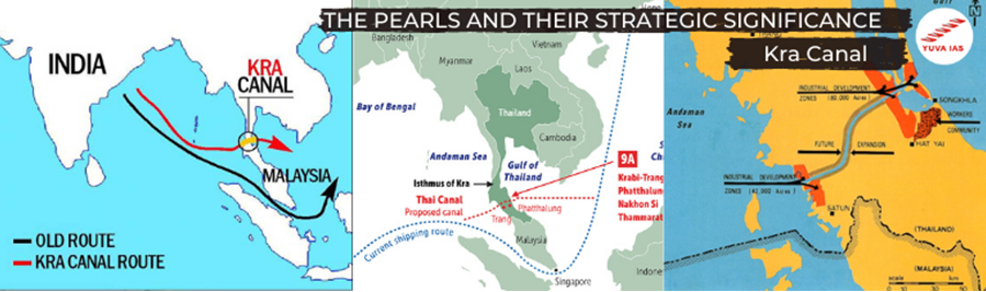
Kra Canal or the “Thai Canal” is actually a plan for a large canal that would cut through Southern Thailand to enable improved transportation in the region.
China had planned to construct this over ten years employing 30,000 workers with an estimated cost of $20-25 Bn. However, initially the plan seemed to have been dropped owing to environmental concerns but recently there have been signs of revival of this plan since there are economic benefits for China and a threat of piracy in the Strait of Malacca. The plan was tentatively approved in 2007 but Singapore and US showed their dissent for obvious reasons.
Another alternative to this plan is to build a pipeline across the Isthmus to carry oil to ships waiting on the other side.
South China Sea
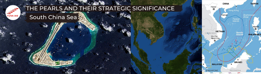
South China Sea is located south of China and Taiwan, west of Philippines, North West of Malaysia, North of Indonesia and East of Vietnam. The region has proven oil reserves – 7.7 billion barrels (28 bn estimated) and its natural gas reserves are estimated at 7500 km3.
A significant part of this region is the Spratly Islands where oil was discovered in 1968. It has been estimated by the Geology and Mineral Resources Ministry of People’s Republic of China that Spratly islands may have oil reserves to make them the fourth largest reserve bed in the world. Hence, there is intensification by PRC to claim these islands.
Woody Islands
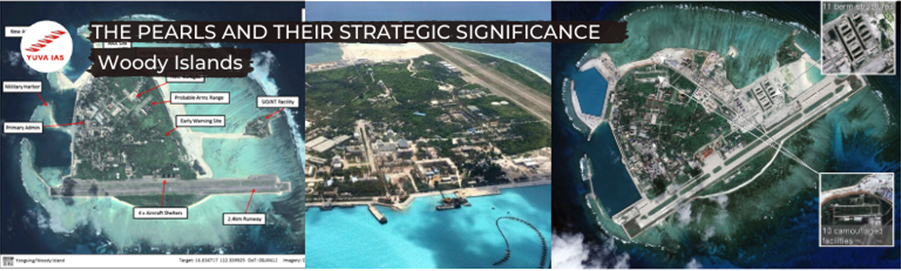
Woody Islands are a part of the Paracel Islands occupied by PRC. This node acts as a Chinese Emergency Rescue Centre served by an artificial harbour and an airfield with a 2350m runway. The centre was occupied in 1956 and also has oil tanks, gun emplacements and ammunition storage bunkers.
In mid ’95, a new SIGINT station was established on the Rocky Island, north to Woody Island. Since it is the highest point, there is good signal interception is obviously good.
Hainan Islands
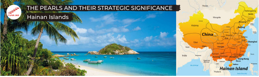
These 200 islands form the smallest province of PRC and are home to the PLAN strategic nuclear submarine naval harbour that is capable of hiding up-to 20 nuclear submarines from spy satellites.
{{doubts.user.firstName}}
{{doubts.createdAt | formatDate}}